Summary
In Rejosari, a small natural drainage channel has evolved into an active landslide corridor. This article invites readers to understand that the core issue at the site is not merely slope failure, but water management that continues to amplify the damage.
A Gradual but Visible Landscape Transformation
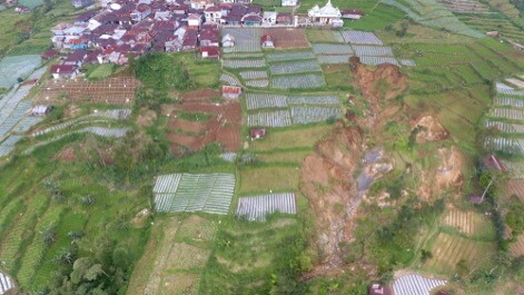
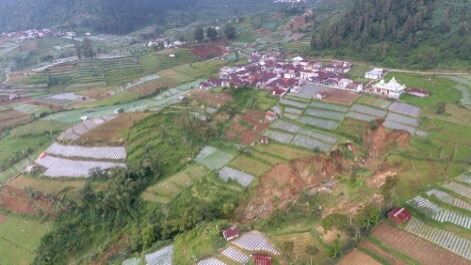
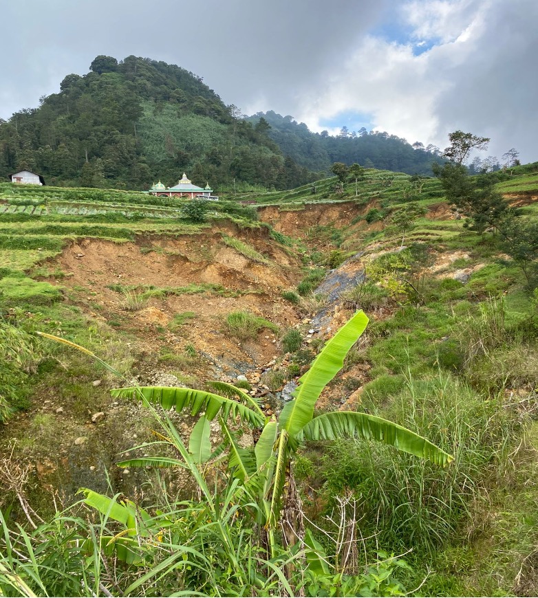
North of the Rejosari hamlet mosque, in Tlogohendro Village, Petungkriyono Subdistrict, a landscape transformation is unfolding—slowly, yet unmistakably. An area once known as a transitional or cultivated land with a small natural drainage channel has now developed into an active landslide–erosion–flow corridor extending from upstream to downstream.
This transformation did not occur overnight. It has evolved over time, driven by increasing water pressure, weakening slopes, and the loss of protective vegetation that once helped stabilize the soil surface.
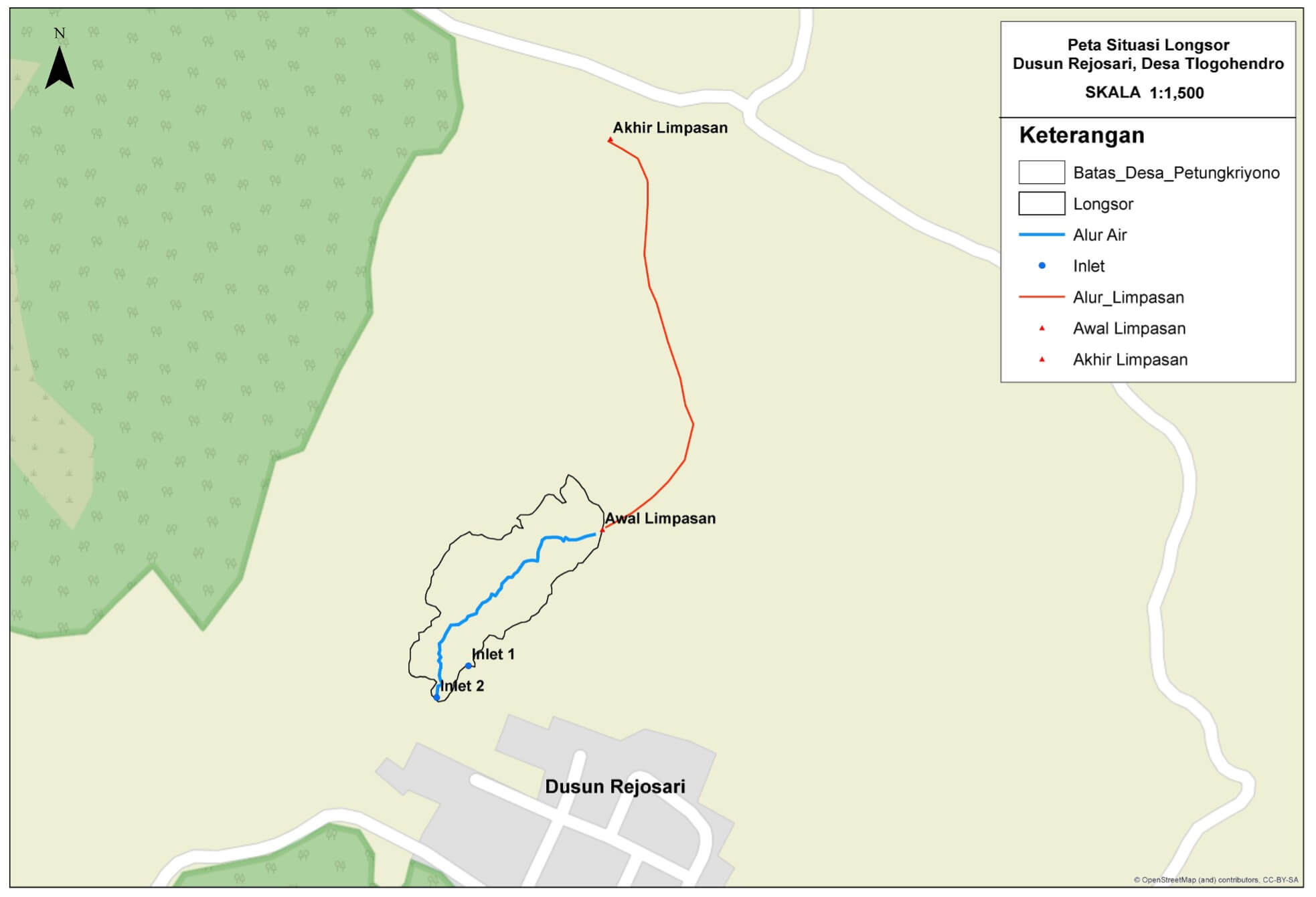
Based on preliminary field data, the affected area covers approximately ±5,520 m², with a landslide body length of about ±155 meters, runoff length of ±248 meters, and slope heights ranging from 10 to 20 meters. What appears on site is no longer a single landslide point, but a continuously evolving system of degradation: a steep head scarp, deepening erosion channels, cut sidewalls, and an active base flow. In this context, the landslide is not merely an event, but an ongoing process.
When Water Becomes the Primary Controlling Factor
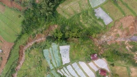
The Rejosari case clearly demonstrates the dominant role of water. The sources intensifying the situation come from two directions: runoff from settlements or upper areas, and natural springs or seepage around the site. The combination of these two sources continuously increases the discharge within the landslide corridor.
What was once a small drainage channel is no longer capable of accommodating this water pressure. As a result, the channel bed is continuously eroded, sidewalls lose structural support, and secondary landslides become more likely.
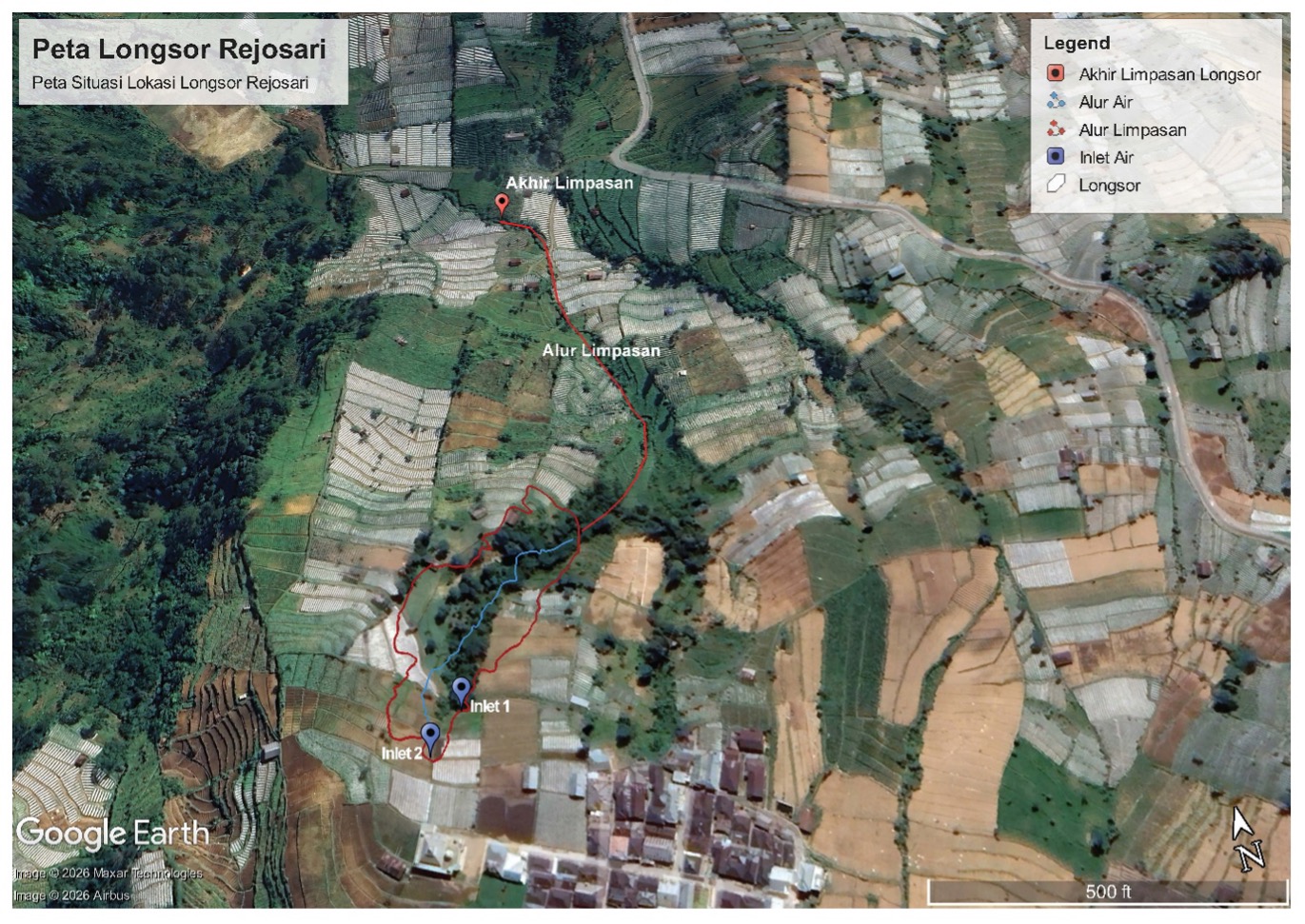
The map clearly illustrates the relationship between landslide areas, active water channels, upstream runoff paths, and inlet points. For general readers, this is important because it shows that the damage in Rejosari is not confined to a single slope, but is influenced by how water moves across the entire surrounding landscape.
Recurring Landslides, Escalating Threats
Local residents report that this area has experienced repeated disturbances. At least three major landslide events have been documented, around 2022, 2024, and 2025. The first major event initiated the damage corridor. Subsequent events expanded the impact, as the slopes had already been weakened. By 2025, the damage had become the most severe, indicating increased water discharge and further degradation of soil structure.
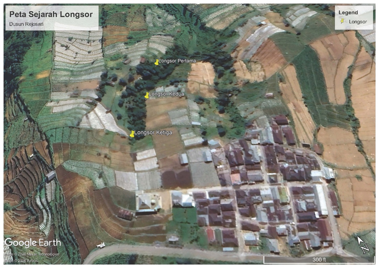
When read alongside field documentation, this pattern reveals a critical insight: without water control, landslides do not stop at a single occurrence. They recur, deepen the channels, widen the corridor, and gradually shift the safe boundaries between cultivated land, community activity zones, and hazard-prone areas.
Why Vegetation Alone Is Not Enough
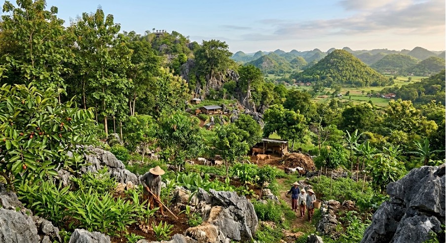
Before the landslide expanded significantly, the surrounding area still contained various types of vegetation, including bamboo, sinder malam, banana, acacia, jackfruit, calliandra, and various weeds. These plants helped stabilize the soil surface and maintain moisture naturally.
However, over time, vegetation alone is insufficient to counter increasingly severe hydrological pressures. As both the volume and duration of water flow increase, slopes are subjected to forces far beyond what ordinary vegetation cover can withstand.
The key lesson from Rejosari is that landslide mitigation cannot begin with planting alone. In such conditions, water control must be the primary prerequisite. Runoff entering the landslide corridor must be identified and diverted as much as possible. At the same time, activities near the landslide edge and steep slope segments must be restricted, as these areas remain highly vulnerable to further collapse.
Key Point
In locations like Rejosari, revegetation will only be effective once water entering the landslide corridor has been controlled and critical eroded segments have begun to stabilize.
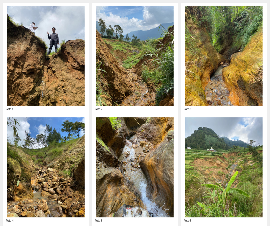
Reading Photos, Understanding the Process of Degradation
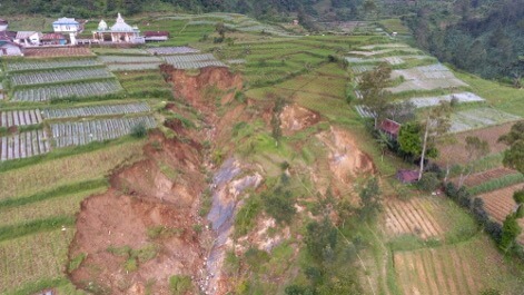
Field documentation reveals several clear warning signs. The landslide head scarp appears steep and exposed, indicating upstream retreat. In other sections, water flow has carved the slope into narrow and deep corridors with high energy. In several points, rocks and sediments accumulate at the base, indicating that water has sufficient force to transport material and continuously expand the damage corridor.
These images are important not only as documentation but also as a shared interpretative tool. From them, we understand that what is happening in Rejosari is not simply soil collapse, but an interaction between water, slope dynamics, weathered material, and land use—all reinforcing one another.
Management Direction: From Water Control to Slope Recovery
In the short term, the necessary technical steps go beyond topographic surveys and simple drainage mapping. A deeper understanding is needed of the relationships between upstream areas, inlet points, the landslide corridor, and downstream outlets.
From this understanding, a more appropriate intervention strategy can be developed: upstream water regulation, flow diversion, protection of critical segments, and identification of zones stable enough for revegetation.
In other words, vegetation—including bamboo—remains important, but should be positioned as a supporting element in relatively stable zones, not as the sole solution in the still-active core corridor. Rejosari teaches us that understanding landslides also means understanding the relationships between water, vegetation, slopes, and human activities.
Beyond Disaster Response
For Relung Indonesia Foundation, situations like this reaffirm the importance of assistance that goes beyond reforestation efforts. It must also address water management, the safety of community living spaces, and more appropriate slope recovery strategies.
Rejosari is not only about landslides that have already occurred. It is about how we choose to respond: hastily, or with a deeper understanding of the root causes.
When a small drainage channel transforms into a landslide corridor, what is needed is not only rapid action, but also careful interpretation of the landscape. From there, more precise, gradual, and sustainable interventions can begin.
Editorial Note
This article is based on field situation reports, location and historical maps, and visual documentation collected during the initial assessment in Rejosari. This text is intended as public communication material and does not replace detailed geotechnical or hydrological studies.
Contributor:
Meiardhy Mujianto
Field Assessment Results:
Fadhli Addifa F